Guide to Svatošské Skály Hiking Trail Map Difficulty
Looking for a scenic walk near Karlovy Vary? The Svatošské skály hiking trail map difficulty is surprisingly low for such dramatic views. This trail follows the Ohře River through a lush protected landscape. It is one of the most popular Svatošské skály rock formations hike options. You will see massive granite towers that look like a petrified wedding party. This guide helps you plan your journey through this legendary valley in 2026.
- Best overall: The Petrified Wedding rocks
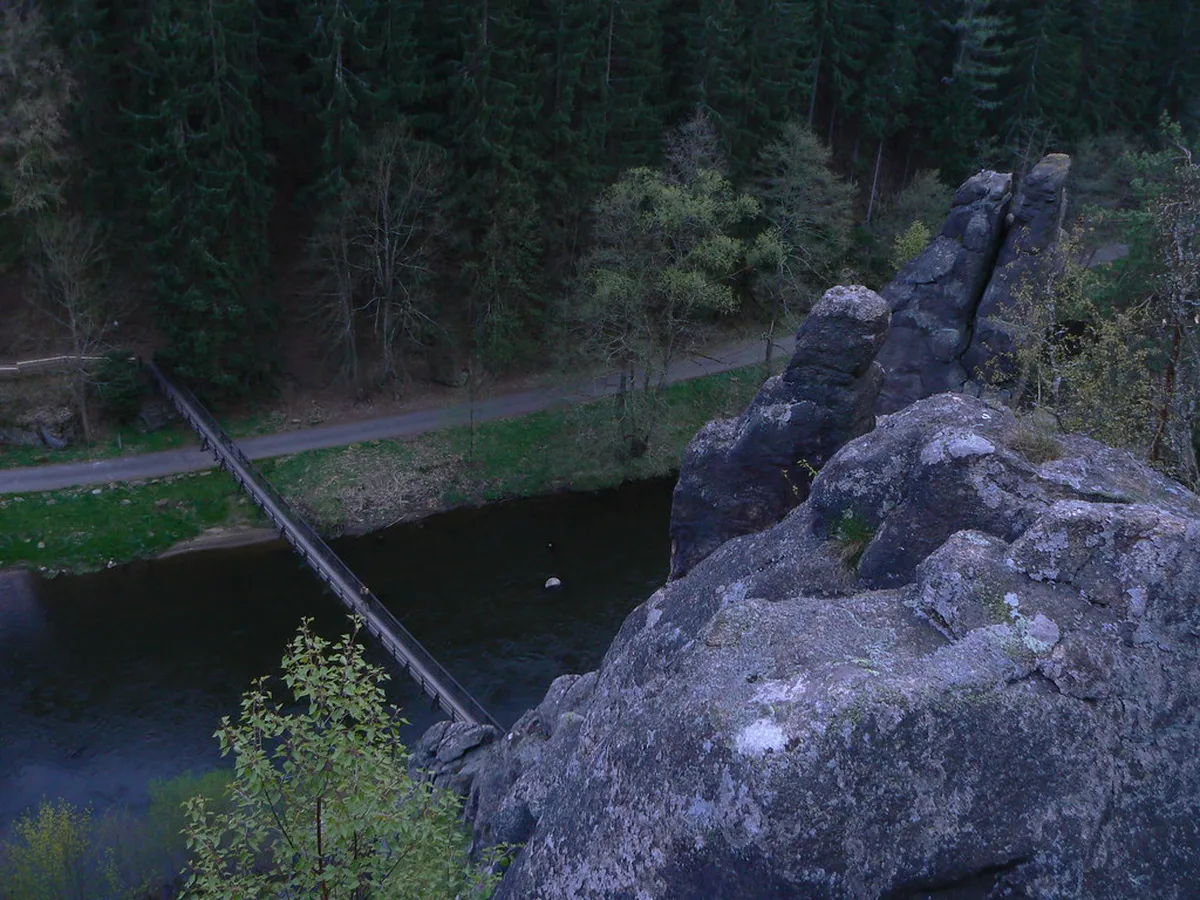
- Best for families: Svatošské Skály Suspension Bridge
- Best rainy-day: Restaurant Jan Svatoš
- Best free: Ohře River Waterfront
Understanding Svatošské Skály Hiking Trail Map Difficulty
Before you start, check the Svatošské skály hiking trail map difficulty levels. Most hikers find the main path very easy. It is a flat, paved route that runs along the riverbank. This makes it one of the best day trips from Karlovy Vary for all ages. You can find official maps on the Karlovy Vary Official Tourism website.
The trail is roughly 10 kilometers long if you walk to Loket. However, the main rock formations are only 2.5 kilometers from the start. Elevation gain is minimal on the primary path. The surface is mostly asphalt, which is perfect for strollers and bicycles. It is a relaxing walk through a deep river canyon.
If you choose the forest trails above the canyon, the difficulty increases. Those paths are steep and can be slippery after rain. These routes are better for experienced hikers with sturdy boots. Most tourists stick to the river path for a leisurely experience. Always check the weather before heading into the woods.
9 Best Stops on the Svatošské Skály Hiking Trail
The valley offers more than just rocks. Here are nine specific spots to visit during your hike. These locations provide the best views and rest areas along the route.
- Name: Doubí Entry Point Type: Trailhead Why go: This is the easiest start for the hike. Best for: Families and casual walkers. Where: Doubí neighborhood, Karlovy Vary. Time: 15 minutes to reach the forest. Cost: Free. Getting there: Take bus number 6 from the city center. Tip: Look for the blue trail markers immediately.
- Name: The Petrified Wedding Type: Rock formation Why go: These are the most famous granite towers in the region. Best for: Photography and folklore lovers. Where: Central part of the valley. Time: 30-45 minutes of viewing. Cost: Free. Getting there: Follow the main path from Doubí for 2.5 km. Tip: Read the legend of Hans Heiling on the nearby signs.
- Name: Svatošské Skály Suspension Bridge Type: Landmark Why go: It offers a fun way to cross the Ohře River. Best for: Adventure seekers and kids. Where: Directly opposite the rock formations. Time: 10 minutes. Cost: Free. Getting there: Accessible via the main hiking path. Tip: The bridge can sway, so hold the handrails.
- Name: Restaurant Jan Svatoš Type: Experience Why go: It is the perfect place for a traditional Czech meal. Best for: Hungry hikers. Where: Near the suspension bridge. Time: 1 hour. Cost: Moderate (250-500 CZK). Getting there: Located right next to the trail. Tip: Check our list of restaurants near the suspension bridge for more options.
- Name: Ohře River Waterfront Type: Nature Why go: You can watch paddlers and ducks on the water. Best for: Relaxation and picnics. Where: Along the entire trail length. Time: 20 minutes. Cost: Free. Getting there: Follow the path alongside the river. Tip: Bring some bread to feed the local ducks.
- Name: Moučné Pytle Rock Tower Type: Sight Why go: A unique rock pillar shaped like a stack of flour sacks. Best for: Geology enthusiasts. Where: Slightly uphill from the main path. Time: 20 minutes. Cost: Free. Getting there: Follow the yellow markers from the main trail. Tip: This section is steeper than the river path.
- Name: Cihelny Viewpoint Type: Viewpoint Why go: It provides a wide view of the valley and golf course. Best for: Panoramic photos. Where: Southern edge of the hiking area. Time: 15 minutes. Cost: Free. Getting there: Hike toward the village of Cihelny. Tip: The trail here is less crowded than the main rocks.
- Name: Stará Role Forest Path Type: Activity Why go: A shaded alternative to the paved river road. Best for: Hot summer days. Where: Upper ridge of the canyon. Time: 1 hour. Cost: Free. Getting there: Use the green-marked trail from Doubí. Tip: This path is more difficult and requires good shoes.
- Name: Loket Castle Viewpoint Type: Day trip Why go: You can see the medieval town from across the river. Best for: History buffs. Where: Near the end of the trail in Loket. Time: 30 minutes. Cost: Free. Getting there: Continue walking 7 km past the rocks. Tip: This is a great spot to finish your hike.
Planning Your Hike to Svatošské Skály in 2026
Plan your visit to ensure a smooth experience. The trail is open year-round and is free to access. Summer weekends can be very crowded with cyclists and families. Visit on a weekday morning for a quieter atmosphere. Check the Visit Czechia portal for seasonal weather updates.
Wear comfortable walking shoes or sneakers. While the path is paved, you might want to explore the dirt trails near the rocks. Bring water, though there are several seasonal kiosks along the way. Most local restaurants accept cards, but carrying some Czech Koruna is wise. Small vendors often prefer cash for snacks.
If you are staying in the city, consider the logistics. You can walk from the center or take a local bus. Many people also choose to rent a bike for the day. This allows you to see the rocks and reach Loket much faster. Always stay on marked paths to protect the local environment.
Frequently Asked Questions
Is the Svatošské skály trail suitable for children?
Yes, it is excellent for families. The main path is flat and stroller-friendly. Children enjoy the suspension bridge and the folklore stories about the rocks. There are also playgrounds at the nearby restaurants. It is a safe and engaging outdoor activity for all ages.
How long does the full hike take?
A round trip from Doubí to the rocks takes about two hours. If you walk all the way to Loket, plan for four to five hours. This includes time for photos and a quick snack. The total distance to Loket is approximately 10 kilometers one way.
The Svatošské skály trail is a must-see for nature lovers. It combines easy access with stunning geological beauty. Whether you walk, cycle, or paddle, the valley will impress you. Don't forget to check out our Loket Castle guide to finish your day perfectly. Enjoy your adventure in the heart of West Bohemia!
Official resources
Use these sources for official schedules, tickets, routes, and updates.
- Karlovy Vary Official Tourism — unverified: Official DMO site.
- Statutory City of Karlovy Vary — unverified: Official municipal portal.
- Visit Czechia — unverified: National tourism board.
- UNESCO World Heritage Centre — unverified: Official UNESCO listing for the city.
- Lonely Planet Karlovy Vary — unverified: Tier 3 editorial requirement.